Published March 3, 2004 09:10AM
Bragging Rights
Cold Front
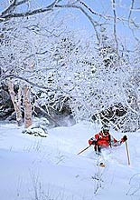
A series of whopper storm systems moved through North America in December and early January. Granted, that was awhile ago, but we wanted to rub it in that the JPEGs your buddies in Salt Lake, Bozeman, and Vermont’s Mad River Valley sent you didn’t need any doctoring. Here’s how the flakes stacked up.
East Coast
The storm that hit the Northeast on the weekend of December 6 and 7 wasn’t supposed to be big—a dusting in the valleys, maybe six or seven inches over the mountains. Too bad “whoops” isn’t a meteorological term, because the upper reaches of New England were blasted with an epic nor’easter that raged for more than 24 hours and delivered 40 to 50 inches of fluff so light it swirled into the air if you so much as sneezed. Then, starting on the 15th, nor’easter number-two pummeled the mountains with more than two feet of powder; on Christmas Day, it started snowing again, and by the 26th, Vermont’s Green Mountains were plastered with 15 inches of fresh, buoying hope for a deep ’04. Then it rained.
ADVERTISEMENT
Out West
Prepare yourself for some downright absurd numbers: By Christmas, 12 feet of snow had buried Jackson Hole up to its rafters, with another five feet dropping by January 2. Whistler was fully operational early, thanks to a 10-foot December. And the day after Christmas in the Southern Rockies, Wolf Creek and Silverton Mountain awoke to a storm that would bring 28 inches in 36 hours. Then, in one incredible 24-hour period, six feet fell on Bridger Bowl. Pretty staggering, until you look at the numbers out of Utah’s Wasatch, where the fruits of a 20-foot December (the state’s snowiest since ’83/’84), were capped with a 104-inch storm that lasted from December 24 until January 2. And still no rain.