Published March 26, 2003 09:20AM
Roemer's Weekly Weather Report: March 24-30
Features
WEEK IN REVIEW
The weather pattern over the last two weeks has replenished snow in parts of British Columbia, Colorado and some other parts of the western U.S. The snow in the east has melted from some of the warmest weather of the winter. Even so, spring conditions at such places as Sunday River, ME, Sugarbush, Mt.Snow and Stowe, VT, are adequate given the good early-to-mid season snows and colder weather.
The blocking high pressure ridge that brought below normal snowfall toUtah, the Sierras and Alaska most of the winter, began to break down inmid-March. This resulted in the air coming from the southwest instead of Canada. This weather pattern change has brought occasional rain and warmer than normal temperatures which have aggravated what has been a decent ski season in New England and throughout the Mid-Atlantic States.
ADVERTISEMENT
The million dollar questions everyone is asking me are:
1. Will there be a spring surprise in terms of a pattern change and snow in the east?
2. Are the incredible snows in Colorado indicative of the weather pattern for the rest of April?
3. Is there any hope for Utah, the Sierra Nevada Mountains and parts of British Columbia and Alberta to salvage what has been a sub-par ski season?
One thing that often happens following a cold winter in the east and a latewinter thaw, is continued “fickleness” of the New England weather pattern. You have heard the old expression by Ben Franklin, “Some people are weatherwise, but most are otherwise.” As soon as society feels they understand the weather and its whims, it turns on a dime. There is proof to the axiom, “If you don’t like the weather just wait a minute, it will change.” Though this axiom has not held true for the aforementioned regions.
FORECAST FOR THE NEXT 10 DAYS
Though the Jackson Hole and Grand Targhee area and much of the Pacific Northwest missed out on the huge Colorado storm last week, this week will feature a nice pounding of at least 5-10 inches from Mt. Baker, Crystal Mtn. and Sun Valley to the Tetons. The first map valid for Thursday illustrates low pressure over central Wyoming. The solid dark green suggests where the heaviest snowswill be. The dashed blue lines indicate the freezing levels below 5,500 feet. One can also see that most of Canada’s freezing level will be below this level, minimizing the affect of warm Pacific moisture that sometimes brings rain and sub-par ski conditions to British Columbia.
The eastern U.S., on the other hand, will continue to have warmer than normal temperatures with readings reaching into the 60’s over much of New England Saturday and Sunday.
ADVERTISEMENT
(Because this is my last report for the winter, I wanted to include two more maps that will give you a “feel” of the early April weather pattern over much of the United States.)
The second map is valid for Saturday, March 30. You will notice a huge low-pressure system southeast of Alaska and north of British Columbia. As this system heads south, above normal snowfall will fall at such areas as Panorama, Whistler, and Fernie and possibly into Alberta as well. With strong systems sliding from Alaska into the Pacific Northwest and British Columbia, this is where I expect above normal snowfall to be as we head into early April. This is much different from the snow nemesis “Pineapple Express” that originates over Hawaii and often brings heavy rains to this region.
This map also shows a good chance of rain in the east this weekend with sub-parski conditions.
ADVERTISEMENT
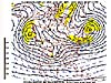
If you recall my March issue of Let’sTalkSkiWeather written in late February, I discussed the reasons why I expected an improvement in the western Canada and Pacific Northwest’s snowfall. This last map depicts the jetstream and winds at 18,000 feet valid for April 4th.
The “X’s” represent disturbances with the expectation of at least normal amounts of snow from Montana, Idaho and Wyoming to Colorado. The 522 “X” you see off the coast of British Collumbia means a lot of snow and colder than normal weather through the first week of April from Oregon, Washington and Idaho intoAlberta and British Columbia. If you are planning a ski trip to Mt. Hood, Whistler, Mt. Baldy, Jackson Hole, Grand Targhee, Fernie, Banff, Lake Louise or Sun Valley, these may be the places to be in early April with above normal snowfall expected. It would not surprise me if some areas in British Columbia and the Pacific Northwest see 4-6 feet of snow over the next 10 days or so.
Helisking will be awesome in that region. Some of this moisture may move into snow-starved Utah and Tahoe, but most of the heaviest snow will stay to the north.
ADVERTISEMENT
I do expect a return to colder than normal conditions in New England by April 1, with rains changing to 2-6 inches of snow by then across N. Vermont, New Hampshire and Maine. Colder weather and the possibility of one last Nor’Easter storm around April 4, may allow eastern skiers to dig out their skis for one last track on northern New England powder. Areas such as Sugarbush, Mad River Glen, Smugglers’ Notch, Stowe, Jay Peak, Whiteface Mtn., Gore, Cannon Mtn., Waterville Valley and some areas in Maine could be in for one last powder hurrah.
We would appreciate your comments about our weather forecasts and what you would like to see for next year at snow@bestskiweather.comIf you are interested in my unique ski-weather newsletter, please e-mail me. Continue to monitor this season’s snow at www.bestsnow.net